WASHINGTON COUNTY HISTORICAL SOCIETY (Washington County, Utah)
NOTES ON THE HISTORY OF THE KOLOB CANYONS
by Steven H. Heath
The author, Steven H. Heath, is a Professor Emeritus of Mathematics at Southern Utah University (SUU). He is a past president of the Old Spanish Trail Association (OSTA) and is currently the Utah Chairman of that organization.
An 1826 Inscription
Thursday, October 21st, 2010Issue 38.10
Part 1
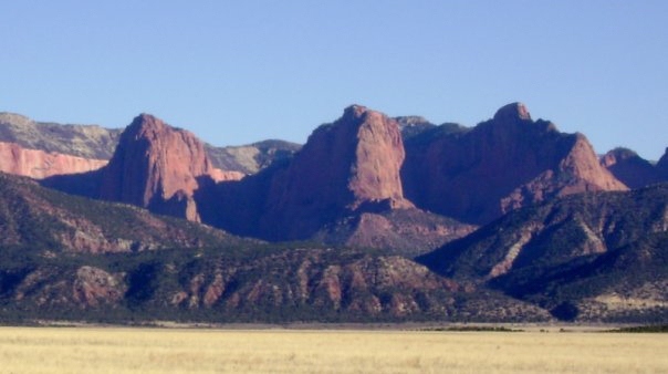
Until 1967, the Kolob Canyon section of Zion National Park was among the most difficult places to access in southern Utah. Even today with highway access off I-15 at exit 40, few take the thirty minute five mile drive to see the greatest natural wonder adjacent to the interstate on its 1340 mile traverse of California, Nevada, Arizona, Utah, Idaho, and Montana. The word Kolob comes from Mormon scripture and means "Nigh unto the Gods." [Pearl of Great Price, Abraham 3:3] Mormons looking upon these majestic sandstone cliffs from New Harmony must have thought they were near God. In addition to the wonderful scenery, Kolob has a rich and interesting human history. The first recorded description of the region comes from the journal of Silvestre Veley de Escalante. Fray Francisco Atanasio Dominguez and Escalante left Santa Fe, New Mexico seeking an overland route to Monterrey, California in July 1776. Early October snow storms turned the ten man expedition south towards the New Harmony, Utah area. The party passed the mouth of Taylor Creek on October 13, 1776, but like travelers today, they were too near the eastern edge of the valley to notice the cliffs. Further south near present-day Hurricane, Utah, Escalante described the region as "all mesa-strewn land." [Warner, 78]
The next recorded trek near Kolob came fifty years later as mountain man Jedediah Smith retraced the Dominguez-Escalante route from Cedar City to Hurricane from September 18-21, 1826. Searching for beaver, Smith and his party traveled south from the annual trappers rendezvous at Bear Lake, Utah. Instead of following Ash Creek to the Virgin River, which Smith named the "Adams River", his party turned to the southwest to the base of the Pine Valley Mountains to cross the Black Ridge. [Smart, Old Utah Trails, 32] Their view of the Kolob would have been extraordinary from that position. Smith's only diary comments on the country was its "unwelcome appearance" and the "detached hills" on the east are "somewhat higher." [Brooks, 55] Smith's return to the area in 1827 helped open up the western half of what would become the Old Spanish Trail, a major trade route from Santa Fe to Los Angeles, California. [Crampton, In Search of the Old Spanish Trail] Exploration of the Kolob Canyons would have to wait until the Mormon settlement of southern Utah, which is the subject of the next episode of this series.
What Lofty Spires! What Turrets! What Walls!
Thursday, October 21st, 2010Issue 39.10
Part 2
Following the arrival of the Mormons in Utah in 1847, Brigham Young sent exploring parties in every direction from Great Salt Lake City to search for possible settlement sites. In November 1849, Parley P. Pratt led an expedition into future Iron and Washington counties. Near Parowan, Pratt divided his group: one under the leadership of David Fullmer stayed in the Parowan area to explore and Pratt led a second party south to the St. George area. His group like Dominguez and Escalante and Jedediah Smith, went over the rim of the Great Basin. Pratt wrote in his journal:
"From the Basin Rim 13 miles of rapid descent brought us to milder climate and first (Indian) cultivation. A mile or so farther brought us to the banks of the Virgin. The great Wasatch range along which we had traveled our whole journey terminates in several abrupt promontories." [Utah Historical Quarterly (UHQ), Volume 18 (1950), Page 133]Some have conjectured that Pratt and his party assigned the name Kolob to the canyons they passed, but the official party journal makes no mention of such a designation. Pratt's party after exploring along the lower Virgin River and Santa Clara Creek returned to Parowan by way of the Old Spanish Trail. Their discovery of iron west of future Cedar City led to the settlement of Iron County in January 1851.
By 1854, in addition to the communities of Cedar City and Parowan, an Indian mission and farm was established at Fort Harmony just east of present day New Harmony. The grand beauty of the Fingers of the Kolob was daily presented to these settlers. Thomas D. Brown, secretary of the mission wrote describing the scenic features of the Kolob and Zion area:
"What abrupt terminations are these to the two chains of mountains east and west, like leaping places at the world's end? But see over Ash Creek to the east, what table lands are these broken off so abruptly? By floods of water? What lofty spires! What turrets! What walls! What bastions what outworks to some elevated Forts! What battlements are these? What inaccessible ramparts? From these no doubt is often heard Heaven's artillery cannonading. What guards patrol these boundaries of the northern Rio Virgin?" [Brooks, Brown Diary, 46]It is likely that missionaries and perhaps Brown himself were the ones who suggested the name Kolob for the region east of Harmony. In his mission journal, Brown writes a poem inspired by admiration of Kolob Canyon. It is entitled the "Missionary Song" and in it he mentions Kolob as the place from which the missionaries' fathers had journeyed so that they could preach salvation to the Indians. The magnificent view is still had by those who drive west to New Harmony then turn around for the incredible scene to the east. Take the trip to New Harmony on clear day with a few fluffy white clouds in the sky. Next week we journey into the Kolob Canyon for an early impression.
From The Journal Of Wilford Woodruff
Thursday, October 21st, 2010Issue 40
Part 3
The first recorded journey into the Kolob Canyons was by Mormon Apostle, Wilford Woodruff. Woodruff, an avid fisherman, went fishing in Taylor Creek in the spring of 1854. His journal reports his fascination with the place:
This is the summit or rim of the basin. We then rode to dry or Battle {Taylor} Creek. Here we have splendid mountain scenery of red rocks standing like pyramids 1,000 feet high. Opposite of this cite is fort Harmony to be located 6 miles from the base of the mountain on the east the fort on the west. ... This is a good grazing country and splendid mountain scenery. ... I went fishing but caught nothing though it was said that there were some small trout in it. I went onto the top of the canyon through which runs Ash Creek 1/2 mile south of the fort in company with T Bullock & Samuel Atwood & in about two hours we rolled into the canyon 1000 feet below about 50 tons of rock. We rolled one would weigh about 5 tons. It fell about 200 feet perpendicular struck a shelf of rock & took the shelf with it. It landed in the creek & sent a sh(ot) of water about 50 feet into the air. We made a good deal of thunder for a while. [Woodruff Journal 19 May 1854; Vol. 4:276-277]
Most including the National Park Service would frown on such activity today, but rock rolling was a common practice with the early pioneers. On Saturday 17 July 1847 in far western Iowa Thomas Bullock recorded the following:
"About 2 P.M. H.C Kimball, W. Richards, E.T. Benson, G.A. Smith John Pack, H. Egan, T. Bullock, E. Snow, & Lorenzo Snow, & Albert Carrington, ascended a very high & steep hill, & prayed to God for the Sick to be healed, the Camps to be prospered, the Saints to be blessed. They amused themselves by rolling large rocks down the hill." [Thomas Bullock Journal]Near Pipe Spring on 28 October 1854, Thomas Brown records a rock rolling episode, which scared the local Indians. [Brooks, 94] Azariah Smith of the Mormon Battalion records another rock rolling experience from a volcanic peak along the Gila River the day after Christmas, 1846:
"This evening I and Father {Albert Smith} climbed a very high mountain with several others and rolled down rocks." [Bigler, Smith Journal, 64]At present-day Palm Springs members of the battalion after washing their clothes and cleaning their guns, "amused themselves by rolling large boulders down the mountain that shook the earth and made a loud noise like peals of thunder, shaking the earth." [N. Ricketts, The Mormon Battalion, 114] Rock rolling was a fun practice and the Kolob was a wonderful and fascinating place to visit and it gave Woodruff and his companions an excellent opportunity to express some boyhood joys. The Kolob as we shall see was also a nice place to hide. Next week we will explore one of the most famous such events, the case of John D. Lee.
From The Journal Of John D. Lee
Thursday, October 21st, 2010Issue 41.10
Part 4
Twenty months after the infamous Mountain Meadows Massacre, the United States government sent Judge John Cradlebaugh, escorted by a military patrol, to investigate the massacre and arrange for surviving children to be sent back to relatives in Arkansas. Cradlebaugh sought earnestly to interrogate John D. Lee and Philip K. Smith who were rumored to have been participants in the massacre. Smith was serving as bishop at Cedar City at the time of the massacre and Lee as Indian agent. Lee and Smith decided that it would in their best interests to avoid Judge Cradlebaugh by hiding out at Virgin or "Pocketville" and then in the Kolob canyons.
Wishing to avoid an encounter with U.S. troops on the roads between Pocketville and Harmony, Lee and Smith concerned about families set out for Harmony by way of LaVerkin Creek. Lee's journal for 11 May 1859, the day they left Pocketville, reads:
"We then got up our animals and bent our course across the mountains up Leverkins about 12 mi. distant from this place {Pocketville} and camped by a precipice of lime stone rock."The next day the two men rode their horses along the top of the Black Ridge but became separated when Lee went to look for a revolver that had fallen from his horse without notice. Lee camped alone the night of 12 May. The next day he recorded the following:
"Started in pursuit of my partner, P.K. Smith. Followed his tracks from range to canyon over the roughest country that I have ever traveled before, and came up with him on Dry Canyon {Taylor Creek} some 6 mi. east of Harmony." [Brooks, J.D. Journals]The next day Lee and Smith observed the comings and goings of the people at Harmony with Lee's spyglass. Lee made contact with family but remained camped in the mountains above Taylor Creek with Smith. He learned from his Harmony contacts that Cradlebaugh had offered a $5,000 reward for his capture. Smith left Lee a short time after this initial contact with Lee's family. One of the interesting entries in Lee's journal is his description of a waterfall at the base of the cliffs on Taylor Creek that he used to clean up with. A short hike up Taylor Creek from the base of the limestone cliffs in the spring leads one directly to the fall he describes. It lies a little further east of a small fall, which is located at the mouth of the canyon. It is a short and enjoyable hike when the water is running.
Lee, who was frequently visited by family during the ordeal noted on 23 May: "Shell Stoddard took dinner with me, it being the first meal I have eat in my house in 4 weeks." Lee's adventure resulted in the naming of the pass between Taylor Creek and the head of Timber Creek after him. It is at the steepest part of the road into the Kolob Canyon. The Kolob was an excellent hiding place for Lee. The next recorded entrance into Kolob came in 1866. This will be next week's adventure.
Jackson's Sketch
Thursday, October 21st, 2010Issue 42.10
Part 5
Visiting the Kolob was not a regular practice in the early Mormon settlement period but occasionally a curious few would venture into it. This was especially true after a road was established between Cedar City and St. George. One such visit was made by the twenty-four year old William Henry Jackson, who was seeking adventure in the west. Jackson, not yet the famous photographer of the American west, had arrived in Salt Lake City in December 1866. A companion, Billy Crowl, and Jackson decided to continue on to California and after arranging passage with the Ed Webb cattle drive, they headed for Los Angeles on 21 December. Jackson kept a detailed diary of their trip. The party passed through Cedar City on 6 January 1867. The next day they were near present-day Kanarraville. Jackson described the scene:
Went ahead of the train some ways. In the canon that Ash Creek flows were some magnificent Red Buttes, apparently two or three hundred feet high. Made two sketches of it from the road. Bill & I took a run up into the canon & made a sketch there. Very romantic spot. Got some ways behind & did not catch up until the train camped at Kelsey's ranch under the Black Ridge. [Hafen, Diaries of William H. Jackson, 111]As far as is known, Jackson's sketches of the Kolob on 7 January were the first ever made of the Kolob. Fortunately for us these historic sketches have been preserved.
Other visits have also been recorded. In 1871, two New Harmony boys, Orin Kelsey and D.S. Clements carved their names in the cliffs near the head of the middle fork of Taylor Creek. Kelsey, who was nineteen years old in 1871, lived in New Harmony for his entire life. [ICR 17 May 1924] What became of Clements is unknown. Another glimpse of the Kolob in this time period comes from the pen of Mrs. Thomas L. Kane. The Kane's in the company of Brigham Young, who was on a visit to southern Utah in the summer of 1872, were given a tourist's view of the wonders of the Zion National Park area. Mrs. Kane recorded her reaction in her trip journal:
Before sunset we caught sight of a great mountain ablaze with color, which we called Mt. Sinai. It stood apart on our left, half withdrawn behind two gray masses which we christened the Twin Friars: a natural rock portal revealing the entrance to a gloomy canon at their feet. ... For the gorge we were passing was Kannarra Canon, the true name of the great mountain was the peak of Kannarra, and the desolate ruins at hand were the abandoned village of Kannarra {Fort Harmony}, from which the wind {and floods} had driven the settlers. [Kane, Twelve Mormon Homes, 130-131]A few days later the Kane's were treated to a closer look at the wonders of Zion Canyon and Mrs. Kane wrote: "But I could never again experience the bewildered admiration I felt that day. No one had prepared me {nor could they} for such a scene." [Ibid, 150] In our next episode we examine the first scientific exploration of the Kolob.
A Two Year Mapping Project
Friday, October 22nd, 2010Issue 43.10
Part 6
The first formal study and mapping of the Kolob region was made in 1872 and 1873 by John Wesley Powell and his Colorado River Survey. Powell, who traveled down the Colorado River in 1869, returned for a two year mapping project on the river in 1871 and 1872. The survey established winter quarters in Kanab, Utah and from there they began a systematic survey of southern Utah and northern Arizona. They would spend most of the rest of the decade at this pioneering work.
In the fall of 1872, a party of Powell's men was at Glendale, Utah on the east fork of the Virgin River. Stephen V. Jones, leader of the group, was charged with finding the headwaters of the Springdale branch of the Virgin {North Fork} and then return to the Virgin River below Springdale. From Glendale, the route took the party up the east fork of the river, west to the edge of the pink cliffs near present-day Strawberry Point, across the head of Deep Creek, southwest across the Kolob Plateau to the western edge of the Kolob Canyons, onto North Creek and finally to Virgin, Utah. On 22 October, Jones described in a succinct journal entry: "Still South 2 miles over a plateau rising fast, no timber, until suddenly we came to a sharp line of cliffs down which we could look 1500 feet. A stream {LaVerkin Creek} rose out of the foot of the cliff and ran nearly south into a deep canon far below us." [UHQ 16-17:165-166] Later on the same day, the Jones party met a Mr. Berry who was tending a community cattle herd. He told them that they could not get down LaVerkin Creek. Jones used the word "Colob" many times in his journal on this trip clearly indicating common usage of the name by 1872.
Part 6 will be concluded next week.
A Two Year Mapping Project
Friday, October 29th, 2010Issue 44.10
Part 6 Conclusion
In 1873, Powell hired western artist Thomas Moran to sketch the Grand Canyon, Zion Canyon and the surrounding area. Moran left Salt Lake City for Kanab in early July. On his way south with J.E. Colburn, a writer for the New York Times, and Powell's secretary, James C. Pilling, Moran stopped to sketch several scenic spots in Utah including the Kolob. [Lindstrom, Thomas Moran in Utah] On 22 July 1873, Moran made his way up Taylor Creek and sketched Tucupit Point, which Moran named Colburn's Butte for his traveling companion. When he returned to the eastern US later in the year he made a woodcut of the scene. It was published in The Aldine- The Art Journal of America in 1874. The woodcut gave the outside world the first view of the Kolob and its majestic fingers. In describing the piece, the editor of the journal wrote:
The subject of another of Mr. Moran's superb illustrations is Colburn's Butte in Kannarro Canon. Kannarro is a small Mormon village in Southern Utah, nestling at the foot of lofty mountains and near the terminus of the ranges extending south from Salt Lake City. Kannarro Canon is a pass in the mountains, some five or eight miles south of the village; and it is in this canon that the visitor receives the first hint of that glorious region to the south, viz., the canon of the Colorado River of the West. Here are first seen those wonderful masses of red sandstone that, a little further south, become overwhelmingly stupendous, staggering belief in their vastness and magnificent forms. The butte in the illustration is two thousand feet high, and of brilliant hue. It is equally grand and beautiful in storm or sunshine. [The Aldine, 1874-75; 15]
Moran later said that the brief time in Zion Canyon alone was worth the trip to the West. [NY Times, 4 September 1873] The departure of Powell and his men from the Kolob Canyons left them to the few locals who ventured to visit them.
Getting To The Rim Of Zion Canyon
Thursday, November 4th, 2010Issue 45.10
Part 7
The departure of Powell and his men left the Kolob Canyons to interested locals to explore. Southern Utah cattlemen succeeded in constructing a trail off the Kolob Terrace into Willis Creek onto LaVerkin Creek and down to the settlements of Toquerville, LaVerkin, and Hurricane. The trail was used regularly by ranchers by the turn of the century. Modern day hikers can still use the steep trail to travel from Kolob Reservoir into the lower Kolob region and its wonderful sites.
In the summer of 1917, Douglas White, industrial agent for the Arrowhead Trail, a proposed highway from Los Angeles to Salt Lake City, came to investigate the potential for tourism along the proposed route. He brought a Plucky Dork car from the Leach Motor Car Company of Los Angeles and he and his companions secured the services of Richard A. Thorley of Cedar City to guide them to the western edge of Zion Canyon. Despite driving over primitive roads and cattle trails, the car successively made it to the rim of the canyon. Their route was the same followed by hikers on today's upper West Rim Trail. [Iron County Record, 19 Oct 1917]
In reporting the event to the editor of the Iron County Record, Mr. Thorley explained that the route followed should be "regarded as anything but practicable." The objective was to get to the rim of Zion Canyon on any feasible route; Thorley, however, explained that a much better route existed through the heart of the Kolob Canyons. The description follows: "From the state highway up through Dry Creek and over the head of Timber Creek {LeePass}; down to the junction of Timber Creek and LaVerkin Creek; up LaVerkin Creek to Hop Canyon {a tributary of LaVerkin Creek}; up Hop Canyon to Lower Kolob; across Kolob to head of Park {north end of Zion National Park}; cross Park to Wildcat Canyon, which is level of the rim of Zion Canyon." Mr. Thorley further explained that the route "would mean a lot to this section of the country" and that "the scenery would be some of the best in the entire district." [Ibid] It would be fifty years before even a portion of the proposed route was developed. Hikers can still experience the spectacular scenery by hiking down the Kolob Arch Trail and out Hop Valley to the Kolob Canyon Road. It is not an easy hike for the inexperienced.
Early Settlers
Thursday, November 11th, 2010Issue 46.10
Part 8
The first settlers in the Kolob came in the 1930's. Even before 1930, the Samuel Pollock family lived in a house at the mouth of Taylor Creek. The cement foundation for the home is still visible on the east side of I-15 where the freeway crosses Taylor Creek. The Pollock children and their friends were frequent visitors into the Kolob. Double Arch Alcove or "Leda's Cave" was explored by young Leda Pollock and companions in 1915. [Middle Fork of Taylor Creek Trail Guide, 1993]
Taylor Creek attracted three individuals from Cedar City, Gustave Larson, Arthur Fife, and William R. Palmer for possible settlement sites. All three built cabins and homesteaded sections of the canyon. Remnants of the Larson and Fife Cabins can still be seen by hikers on the Middle Fork of Taylor Creek trail. Palmer's homestead and cabin was across Taylor Creek, northwest of the parking lot for the trail. Why the families gave up their claims is not known but it may have been the pressure of the government to create a national monument, which would feature the Kolob Canyons.
The United States Geological Survey and the National Park Service made preliminary investigations of the Kolob in the mid-1930's. The scientific survey was led by retired Yale geologist and veteran surveyor of southern Utah, Herbert E. Gregory. Gregory would write NPS Acting Director, Earl A. Trager his impression of the Kolob region: "If only one spot in Utah and Arizona were available as a platform for a lecture on the geology of the Colorado Plateau country, I think, I would choose Kanarra Mountain were the sedimentary series (Kaibab to Wasatch) is in sight, the Great Basin topography abuts against the Plateau topography, and where the erosion, the faulting, and the volcanism characteristics of the Plateau Province could be discussed and illustrated with nearby examples." [Gregory to Trager, 8 August 1936]
Gregory's recommendation to Trager led President Franklin D. Roosevelt to create a new Zion National Monument encompassing the Kolob Canyons on 22 January 1937. The existing Zion National Park had been designated as Zion National Monument in 1918 right before Congress created Zion National Park. The creation of the new monument on the northeast border of Zion National Park resulted in a new scientific study of the Kolob. In 1940 and 1941, Gregory and a colleague, Norman C. Williams undertook the task. Their study of the new monument was published as "Zion National Monument, Utah" in the Bulletin of the Geologic Society of America in March 1947. It was the first comprehensive view of the Kolob Canyons. One of the features of the study was the little known Kolob Arch. Our next episode will discuss this Kolob spectacle.
Kolob Arch
Thursday, November 18th, 2010Issue 47.10
Part 9
One of the great back country spectacles in the Kolob is its famous Kolob Arch. The arch has a measured span of 310 feet making it the largest free standing arch in the world. In the Gregory and Williams 1947 publication they mentioned its existence on page 16 of the paper. In fact there was a move to name the arch after Gregory but since there was a natural bridge on the Escalante River which bore his name, the proposal was decided against. Besides, the arch was known to cattlemen for at least twenty-five years before. William W. Flanigan, who is famous for his solo descent of the Virgin River Narrows in 1900, accompanied a Mr. Willis into the Kolob in 1922 to look for the arch. [Flanigan Diary 16-17 Jun 1922] They failed in their attempt and as far as is known Flanigan never returned to look for it. Zion park ranger, J.L. Crawford saw the arch from the cliffs of the Kolob in the fall of 1948. The next spring he hiked up LaVerkin Creek into Bridge Canyon and took what was the first photograph of the majestic arch. A couple of years later National Geographic featured Zion National Park and Zion National Monument in the January 1954 issue. They probably published the first photo of the arch and gave it some renown.
Two years before the Guinness Book of World Records listed Landscape Arch in Arches National Monument (now National Park) as the world's longest natural arch span. The claim was based on the measurements of rock climbers Fred D. Ayres and Alex E. Cresswell, who had climbed to the top of Landscape Arch in 1949. [Hoffman, Arches National Park- An Illustrated Guide, 83 & 123] Hearing about the Kolob Arch, Ayres and Cresswell climbed to the top of Kolob Arch on 12 August 1953. Their measurements indicated that it had a span of between 290 and 300 feet and the question of which was the longest was not determined.
In 1983, a team of scientists and engineers determined that the Kolob Arch actually had a span of 310 feet; nineteen feet more than the Landscape Arch. Dale Stevens wrote as a conclusion to the study: "Since aesthetics are also considered by many to be a factor in describing the characteristics of arches, one must not overlook the relatively thin span and distance from nearby rock masses that sets the free standing Landscape Arch apart from the cliff wall position and massive span of Kolob Arch. On the other hand the remote isolated location and brighter colors of Kolob Arch surely make it one of nature's prized possessions to the viewer who enjoys the natural wonders of the world. Both arches are masterpieces of those geological processes that make southern Utah such a unique place." [Stevens, Dimensions of Landscape Arch, BYU Geography Department, 1985; 7] A hike to the Kolob Arch is an incredible experience but not one without challenges, check with a park ranger if you attempt it.
"Mission 66"
Thursday, November 25th, 2010Issue 48.10
Part 10
To commemorate their 50th anniversary, the National Park Service in 1956 proposed sweeping ten-year plan, "Mission 66." The program was proposed to protect, develop, and improve the national parks nation-wide. The plan was studied, developed, and promoted at the local level.. In May 1955, Paul Franke, Superintendent of Zion and Bryce National Parks, announced what he called a "first step" in development of Zion National Monument; the construction of a highway into the monument. After a week-long investigation with regional park officials from San Francisco, he concluded that such a road was feasible. [IC Record, 26 May 1955]
In July 1956, Conrad L. Wirth, Director of the National Park Service announced the details of the Mission 66 proposal to Congress and the American people. Three of the proposals dealt directly with the development of Zion National Monument. The first recommendation was to incorporate the monument into Zion National Park. A second proposal called for two new roads into the Kolob area; one up Taylor Creek and down to LaVerkin Creek and a second road on a spur to Death Point on the eastern edge of the monument. A final proposal called for a new campground on LaVerkin Creek at the end of the proposed road up Taylor Creek. [IC Record, 12 July 1956]
In the fifty years plus years since the announcement, only one proposal and part of another have been completed and the others will probably not be undertaken. The first proposal was completed at the time the Mission 66 plan was being presented. On 11 July 1956, Zion National Monument became part of Zion National Park. Even the New York Times covered the action and published a beautiful photograph of Burnt Mountain to accompany the story. [NY Times, 26 August 1956] Part of the second proposal was achieved by the fall of 1967. An oiled road was completed from I-15 into the heart of the Kolob Canyons. Construction started in the spring of 1964; grading of the road base was completed by the spring of 1966, and paving of the new road was finished the next year. The project, which Richard Thorley suggested in 1917 cost the taxpayers $1,460,000. The 5.2 mile road ended on a hillside overlooking Timber Creek and the spectacular Five Fingers of the Kolob. The road was not completed to LaVerkin Creek as originally planned, so the campground was never constructed, and the road to Death Point was never attempted due to a dispute over private property rights. [NPS, "Taylor Creek Road", 66-87]
With the completion of the road into Kolob a new phase in its history began. We will consider these subjects in the next episode of this series.
New Trails
Thursday, December 2nd, 2010Issue 49.10
Part 11
With the completion of the road into the Kolob in 1967, two major hiking trails were constructed: a 7.2 mile trail from Lee's Pass to the Kolob Arch and a 2.7 mile trail up the Middle Fork of Taylor Creek. In 1995, a trail was constructed to a point south of the end of the Kolob road to an overlook of Timber Creek. There is also a developing trail, still unmarked, to the Elephant Arch (also referred to as the Lee Pass Arch) in the north fork of Timber Creek. The Elephant Arch, which has a span of about forty feet, can be seen from the viewpoints at the end of the Kolob road. It is best observed in the morning hours of the day when the canyon walls to the east of the arch are illuminated. Zion National Park in cooperation with the Boy Scouts of America included the Kolob Arch along with the West Rim Trail and Narrows hike as part of its "Rainbow Canyons" hiking patch that numerous scouts have earned since its implementation in 1964. [IC Record, 18 July 1964]
The next significant event in the history of the Kolob came when Zion National Park as part of its 75th birthday anniversary celebration dedicated a new visitor's center at the entrance to Kolob. The new facility came to the park as a gift from the Zion National History Association, which had spent many years acquiring funds for its construction. Mr. J. L. Crawford, member of the board of directors for the association, presented the $130,000 facility to Lorainne Mintzmyer, park service regional director, at the dedication ceremonies on 31 July 1984. Ms. Mintzmyer told the crowd of about 200 people that Zion National Park was one of three national parks in the country that had immediate access from an interstate freeway. [Daily Spectrum, 1 August 1984]
The new visitor's center led to the publication of a number road and hiking guides specific to the Kolob section of the park. [Kolob Canyons Road Guide, 1993] In addition, the visitor's center provides readily available publications on Zion National Park and other regional national parks and monuments. It also gave the Kolob important ranger services for this section of the park. It is an essential stop for even a brief survey of the Kolob. We conclude this series on the Kolob next week by exploring some of its recent geologic activity.
Conclusion
Thursday, December 9th, 2010Issue 50.10
Part 12
One of the myths that some visitors to the Kolob may have is that it is not changing. Two important events in recent years indicate that the Kolob Canyons are still very active geologically. In July 1983, a major rock fall from the north facing cliffs of Timber Top Mountain showed dramatically how the canyon was formed. Freezing water in the cracks of the sandstone combined with the sun's heating of the cliff surface over many years weakened a section of the rock several hundred feet wide and nearly 1000 feet high and sent it crashing to the canyon floor as rubble. [Kolob Road Guide, Stop 9] Even today, the scar on the face cliff is readily apparent to the visitor to the Kolob from the observation sight at the end of the Kolob road. As with many rock falls, it went unnoticed for some time.
The second and more dangerous event occurred on Wednesday 17 March 1993 around 9:30 am. A ten-foot wall of water and mud came crashing down Taylor Creek and spread across I-15 damaging several passing trucks and cars. Four people were hospitalized in the freak flood. Although it was a clear, dry, beautiful day, spring rains and runoff had backed up behind a natural sand dam formed several years before in a branch of Taylor Creek. Water pressure from spring rains finally broke the dam and thus the water and sand rushed down Taylor Creek to the unfortunate few who were crossing the path of the stream on the freeway at the same time. [Spectrum 18 March 1993; Deseret News 19 March 1993] Geologists would tell you that they have evidence that such events had occurred before and that will occur again.
The study of geology teaches us that nature's processes created the Kolob Canyons, and someday the incredible scenes in this part of Zion National Park will disappear. Fortunately for us, the grandeur of the Kolob will be around for the rest of our lives and many generations of our descendants. The exciting human history at Kolob canyons for the past two centuries only adds to our enjoyment of this incredible region. We hope you have enjoyed reading about this unique place and that you will take the time to go and enjoy our wonderful Kolob Canyons.